
An insight through maps
(Right-click to open in a new tab to see full size)
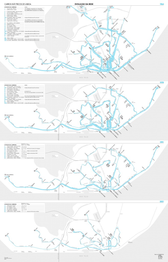
A representation through time of the streetcar network of Lisbon.
This year being the 150 anniversary (1872-2022) of the company which operates this network, here goes a work I did some time ago; it was high time to publish it.
I chose to start from1964 for these reasons:
- The metro was already in service, so the streetcar network had already started to be adjusted (slighly) to not duplicate services;
- I have complete and accurate documentation about the network from that time onward;
- the city of Lisbon was at her historic peak of population (inside the city limits), only met a second time in 1981;
- the network was also at its peak and quite stable for almost 20 years, before rapid downsizing.
The blue is a reference to the medium cyan used from the mid-1960s until the early 1990s to distinguish the streetcar lines from the bus lines (in red) on the network maps.
As it is obvious, the network shrinked spectacularly. What is also to be noted, is that beyond the densest part of this network, inside a circle – formed by (from east to west) Areeiro, Av. João XXI, Av. de Berna, Av. Calouste Gulbenkian, Av. de Ceuta – only three trunks served by 8 branched routes were reaching the farthest parts of the city, which were at the time typical faubourgs, following historic roads radiating to the north and northeast.
So the network was very adjusted to the city as she was at the time, beyond the “linha de cintura” (belt railroad going from the main line starting at Santa-Apólonia, to Alcântara-Terra on the west in a arc of a circle), except for the very old western development along the Tagus to Belém, only few axis of urban developments were existing: Estrada de Benfica, Estrada das Laranjeiras and Estrada de Lumiar, the city possessed an important rural hinterland until late in the 20th century.
It should be added that during the interval separating the 2nd and 3rd maps the city’s population dropped by 17.8% in ten years, and that between the 3rd and the last map, the population dropped in the same proportion but at a much slower pace, over 30 years. The population has now stabilized.
Also, additionally to this drop, there was a strong shift in the repartition of the population inside the proper city limits. The hyper-central freguesias (local equivalent of “borough”), forming the defunct 1º Bairro, counted in the early 1960s 214,107 inhabitants, 26.5% of the total population of the city, over 6 km2, which represents only 7% of the total city’s area (84km2 at the time), giving a high density of 35,684/km2.i
The same area has today slightly over 75,000 inhabitants, whereas entire areas of uninhabited lands located within the city limits were constructed and populated in the 1970s and 1980s. For instance: the area beyond the 2ª circular, and west to the airport to the Estrada da Luz, had only a small populated nucleus, 2.75km away from the upper limit of the first map, by the census of 1960; this area has now 88,000 inhabitants; on the east side, from the airport to the Tagus River, which saw in the late 1950s, the first development of social semi-detached housings to a great scale, Encarnação, is now populated by 55,566.
In fact, the streetcar network which was mostly serving the inner core, shrinked only as much as the population were moving out from this specific area. The type of routing, with numerous circulars functioning in both directions (one number for each), crossing each other, and overlapping on many corridors, gave very heavy service on many streets with no less than 5 to 6 routes in each direction, on Calçada Ribeiro Santos, Rua da Boavista, Rua Jardim do Tabaco, Rua da Escola Politécnica, Rua da Palma, or 3 routes in each direction on Rua Alexandre Herculano, Rua Conde Redondo, Av. Duque d’Ávila, Rua Morais Soares, Rua Janelas Verdes, Av. 24 de Julho.
With the metropolisation of the city, in the late 1980s, the booming suburbs, the social changes leading to a rapid loosening of the traditionnal family and the jobs moving elsewhere in the territory of the city (e.g. Avenidas Novas for the services in the 1990s), as well as the greatest expansions of the subway system so far (the Metro, which is an underground mass rapid transit system, was significantly extended during the late 1990s, with new lines constructed, and a complete restructuration), whereas the streetcar network had to be rescaled, its structure was inherited from the mid 20th century.
This streetcar system is a sort of oddity, its gauge of 900mm is somewhat narrow, it is nothing alike the light rail system of Porto which was created from scratch to cope with the urging needs of mass transit in the sprawling northern agglomeration. The streetcars of Lisbon form an entirely different and singular system, a relic or legacy of what it used to be.
Only one route, the 15E, can be considered as a light rail. This is the riverfront line reaching the western city limit from the northern tip of the Baixa, on which longer and articulated cars (Siemens/CAF and Siemens/Sorefame from 1995) circulate on a segregated way for most of the length, with the use of articulated buses when the fleet of only ten light rail vehiclesii is not enough to cope with the demand. Indeed, this route has a base frequency of 12′ served by cars which can carry 200 people, the maximum capacity per hour per direction is 1000, while for instance, the bus route 728, renforced during the day from Belém (Mosteiro dos Jerónimos) to Santa Apólonia, doubling the 15E along the Av. 24 de Julhoiii, has a capacity of ca. 1057/h/directioniv.
The five other routes are still operated with a fleet of refurbished cars (by 1995) corresponding to needs from more than 80 years ago. These routes except for the 15E and the 18E (using the same segregated way) offer very poor regularity since they share the roads, many of them in narrow streets (hence the initial choose of the gauge), with the general traffic. Double-parked cars being commonplace, it is very usual to see, after an umpteenth random stop of several precious minutes on the busy 28E, three to four cars coming in a crocodile line, the first crowded out, the second half-full, the others empty. The frequency, allegedly about 7/8 minutes, could be actually anything over 15´, with indian lines of three/four cars appering randomly. If it is not of much consequence for tourists, it is deplorable for people who rely on public transport, and reflects very poorly on this system. Most of the remaining routes are in fact still active because of the heavy touristic use, like the 12E, which is a small clockwise circular around the Castle hill.
Nevertheless the transversal 28E, which goes from Campo de Ourique, a densely populated neighbourhood far from the centre to the west, up to Graça, and down to Martim Moniz square, through the famous late-18th century Baixa, is the only remaining “structuring” route along with the 15E. The 28E is doubled on the western part by the 25E which goes to the same western terminal through another part of the city, far calmer and less densely populated.
A route had been partly re-activated some years ago, the 24E, just between the Camões Square and Campolide. This route is under-used, mostly because it would have make much more sense to re-activate the missing 500m stretch, further south, down to the essential transit hub of Cais do Sodré (Metro green line southern terminal, along with a dozen bus routes, two other streetcar routes and boats for the other bank of the Tagus). Without this link, the 24E is doubling an important bus route, with a far better capacity, the 758. Even if the idea was to allievate the 758, the end point of the 24E at Camões Square makes the current 2600m long route of dubious interest in the bigger picture of public transit in Lisbon.
Plans have been announced to built long-expected extension of the 15E to the railway station of Santa Apólonia in a first phase and then all the way up north to the Parque das Nações neighbourhood and the bordering suburb of Sacavém beyond. Another extension has been approved to the west, to the suburb of Linda-a-Velha. Two new lines would be built from scratch, one in the north of the agglomeration, connected to the current northern terminal of the Metro yellow line, and one on the west side, connecting Alcântara with Cruz Quebrada through the densely populated high parts of Ajuda and Restelo neighbourhoods as well as the bordering suburb of Miraflores.
The future of this system lays outside the city limits.
A. B.-M., November 2022
i The average density of the city was 9607/km2, it is nowaday about 6400/km2 (with great disparity througout the municipality, some areas having a density as low as 3000/km2 and some others as much as 16000/km2).
ii For years a set of new cars had been anounced, the contract to buy 15 brand new units, longer (24m) and with a greater capacity (221 passengers), has been signed the 21 April 2022.
iii 44% of the length of the 15E is doubled by the bus route 728.
iv Intervals of 8.5′, served by articulated buses that can carry 155 people (Citaro G NGT), 147 (Citaro O 530 G).
