Skip to content

City & Transit Maps

  • Analysis/On Maps…
  • Quick bio
  • Une rapide bio
  • WordPress.com
  • More about Transit Maps

Aurélien Boyer-Moraes is a graphic designer hailing from France, specialised in cartographic and information design.

  • Home
  • About
  • Transit Maps
  • City Maps
  • Villes Bis
  • Contact

Category: Uncategorized

Circulação (Lx)

My latest map, on an idea which was running through my mind for a while. Just in time for the … More

Cartography, GraphicDesign, Lisbon, Map

Carte du réseau SNCF, 1990

Carte des lignes ferroviaires et routières du réseau voyageurs, service hiver 1990. J’ai trouvé il y a peu un « … More

Cartography, PublicTransit, SNCF, SystemMap, Trains

1938, les plans de réseaux de Marseille et Londres : plus qu’un air de famille.

J’ai trouvé, il y a peu, un plan du réseau des transports publics de Marseille, de la C.G.F.T. (Compagnie Générale … More

Cartography, London, Map, Marseille, NetworkMap, TransitMap

Transports publics de Toulouse, 1974

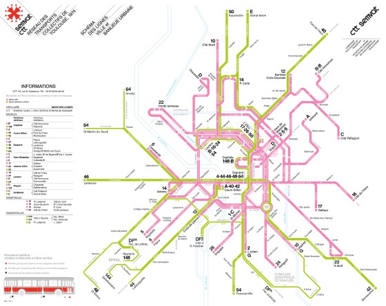
Un nouveau «plan-témoin» d’un réseau à une époque, à Toulouse, en 1974.

Cartography, Map, mobilité, PlanDeRéseau, PublicTransit, SystemMap, Toulouse, TransitMap, Transportspublics

Toulouse public transport draft from Autumn 2013

Apropos my very recent discovery of a sketch of the public transit map of Toulouse from the late 1960s (or … More

Cartography, GraphicDesign, NetworkMap, PublicTransit, Toulouse, TransitMap

Carte du réseau ferré italien

Il y a un peu plus d’un an, j’ai publié une carte du réseau voyageurs de la SNCF en hommage … More

Cartography, GraphicDesign, InformationDesign, Italy, NetworkMap, Train, TransitMap

Presenting a revised version of Barcelona Frequent Map

I was invited to submit a poster for the 3rd Schematic Workshop 2022, which was held last week (April 21-22) … More

Cartography, InformationDesign, Map, PublicTransit, TransitMap

Barcelona: two bus maps.

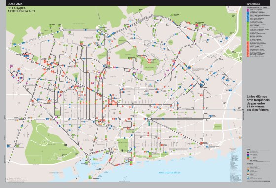
Two solutions, toward a schematic high frequency map. Here go the fruits of my latest and longest work in years: … More

Barcelona, Cartography, GraphicDesign, Infographics, InformationDesign, NetworkMap, PublicTransit, SystemMap, TMB, TransitMap

Turin High Frequency Transit Map

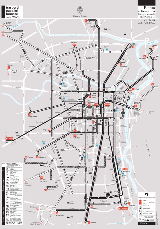
Here goes my last transit mapping project. A high frequency map of the public transport system of Turin, explicitly entitled: … More

Design, GraphicDesign, Graphisme, GraphismeInformatif, HighFrequencyMap, Illustrator, InformationDesign, Map, PlanDeRéseau, Public Transit System, PublicTransitCartography, SystemMap, Torino, TransitMap, TransportsCollectifs, Turin, VectorMap

The “vértigo horizontal” and an urban gridiron: Buenos Aires old streetcar network diagram revamped

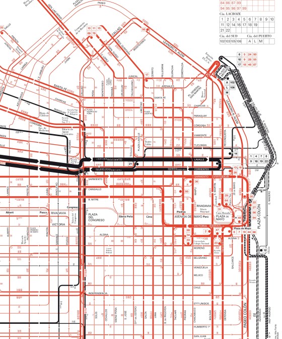
I discovered some time ago an old and outstanding map of streetcar routes of the city of Buenos Aires. This … More

Buenos Aires, Cartography, Diagram, GraphicDesign, Infographics, NetworkMap, PublicTransit, TransitSystemMap, UXDesign, Vintage

Posts navigation

Older posts

  • cityandtransitmaps's avatar cityandtransitmaps
Blog at WordPress.com.
  • Subscribe Subscribed
    • City & Transit Maps
    • Already have a WordPress.com account? Log in now.
    • City & Transit Maps
    • Subscribe Subscribed
    • Sign up
    • Log in
    • Report this content
    • View site in Reader
    • Manage subscriptions
    • Collapse this bar
 

Loading Comments...