Skip to content

City & Transit Maps

  • Analysis/On Maps…
  • Quick bio
  • Une rapide bio
  • WordPress.com
  • More about Transit Maps

Aurélien Boyer-Moraes is a graphic designer hailing from France, specialised in cartographic and information design.

  • Home
  • About
  • Transit Maps
  • City Maps
  • Villes Bis
  • Contact

Tag: InformationDesign

Un brouillon pour un bel imbroglio : le réseau de Montevideo

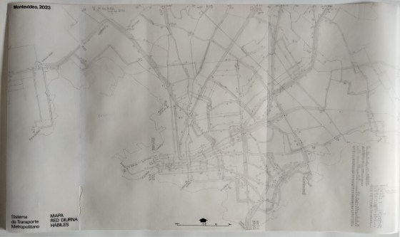
Une fois n’est pas coutume, le plan que je présente est un brouillon, de 73 × 42 cm (l.×H.), fait … More

Cartography, InformationDesign, Montevideo, PublicTransit, SystemMap, Transit

Carte du réseau ferré italien

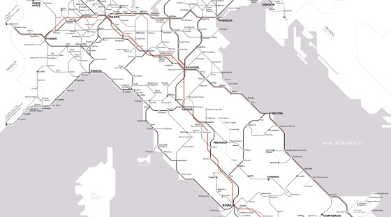
Il y a un peu plus d’un an, j’ai publié une carte du réseau voyageurs de la SNCF en hommage … More

Cartography, GraphicDesign, InformationDesign, Italy, NetworkMap, Train, TransitMap

Detroit 2022 Transportation Guide

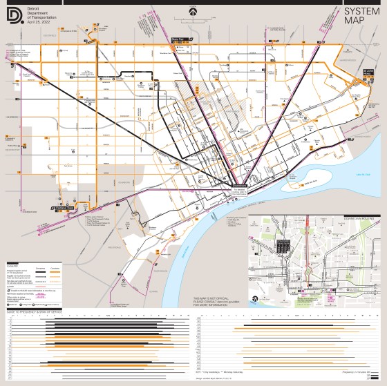
Updating and more. With the return of a level of service to near pre-pandemic, I updated the whole Detroit public … More

Cartography, Detroit, Diagram, GraphicDesign, Infographics, InformationDesign, NetworkMap, TransitMap

Presenting a revised version of Barcelona Frequent Map

I was invited to submit a poster for the 3rd Schematic Workshop 2022, which was held last week (April 21-22) … More

Cartography, InformationDesign, Map, PublicTransit, TransitMap

Barcelona: two bus maps.

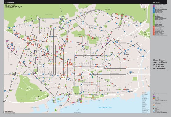
Two solutions, toward a schematic high frequency map. Here go the fruits of my latest and longest work in years: … More

Barcelona, Cartography, GraphicDesign, Infographics, InformationDesign, NetworkMap, PublicTransit, SystemMap, TMB, TransitMap

Detroit Department of Transportation System Map 2021

DDoT System Map (unofficial) updated It was a long time since the last update, since significant steps had been made … More

Cartography, DDOT, Detroit, GraphicDesign, InformationDesign, Map, PublicTransit, SystemMap, TransitMap

Toulouse Transit System schematic map, prototype 10-2013

Update (about the fate of this map)

Cartography, GraphicDesign, InformationDesign, Map, PublicTransit, Schematic Map, SystemMap, Toulouse, TransitMap

Turin High Frequency Transit Map

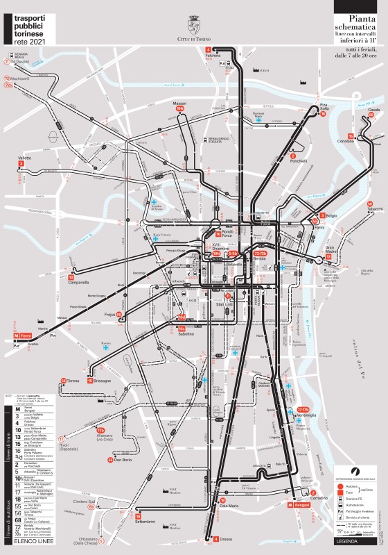
Here goes my last transit mapping project. A high frequency map of the public transport system of Turin, explicitly entitled: … More

Design, GraphicDesign, Graphisme, GraphismeInformatif, HighFrequencyMap, Illustrator, InformationDesign, Map, PlanDeRéseau, Public Transit System, PublicTransitCartography, SystemMap, Torino, TransitMap, TransportsCollectifs, Turin, VectorMap

Coimbra Urban Transport Network Map

Map (unofficial) of the main urban bus and trackless trolleys network of the city of Coimbra.

Cartography, Coimbra, GraphicDesign, InformationDesign, Map, MapaDaRede, NetworkMap, PublicTransitMap, SémiologieGraphique, Semiotics, SystemMap, TransitMap, TransportePúblico

  • cityandtransitmaps's avatar cityandtransitmaps
Blog at WordPress.com.
  • Subscribe Subscribed
    • City & Transit Maps
    • Already have a WordPress.com account? Log in now.
    • City & Transit Maps
    • Subscribe Subscribed
    • Sign up
    • Log in
    • Report this content
    • View site in Reader
    • Manage subscriptions
    • Collapse this bar