Skip to content

City & Transit Maps

  • Analysis/On Maps…
  • Quick bio
  • Une rapide bio
  • WordPress.com
  • More about Transit Maps

Aurélien Boyer-Moraes is a graphic designer hailing from France, specialised in cartographic and information design.

  • Home
  • About
  • Transit Maps
  • City Maps
  • Villes Bis
  • Contact

Tag: Lisboa

Lisbon Carris Map, Winter 2022-2023

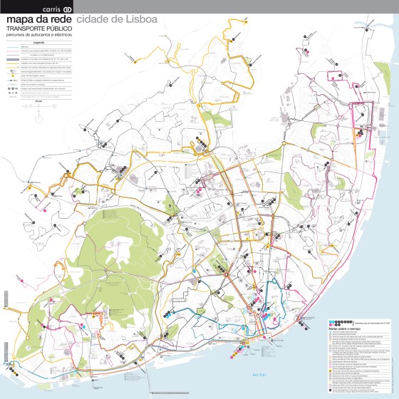
A new attempt at depicting the current public transport network of Lisbon and immediate surrounding communities. (right-click on the map … More

Carris, Cartography, GraphicDesign, Lisboa, Lisbon, Map, NetworkMap, PublicTransit, TransitMap

Lisbon streetcar network, 1964-today

An insight through maps (Right-click to open in a new tab to see full size) A representation through time of … More

Carris, Cartography, GraphicDesign, Lisboa, Lisbon, Lisbonne, Map, NetworkMap, PublicTransit, Streetcar, TransitMap

Public transit network map of Lisbon/Mapa da rede de transporte público de Lisboa (Carris); unofficial

Further about this network map (specially in comparison to the former attempt and different approach displayed on this site, cf … More

Autocarros, Carris, Cartography, Design, Elétricos, GraphicDesign, Infographics, Lisboa, Lisbon, Lx, MapaDaRede, NetworkMap, PublicTransit, PublicTransitMap, Semiotics, TransitMap, TransportTransportePúblicodeLisboa, UXDesign

  • cityandtransitmaps's avatar cityandtransitmaps
Blog at WordPress.com.
  • Subscribe Subscribed
    • City & Transit Maps
    • Already have a WordPress.com account? Log in now.
    • City & Transit Maps
    • Subscribe Subscribed
    • Sign up
    • Log in
    • Report this content
    • View site in Reader
    • Manage subscriptions
    • Collapse this bar