Skip to content

City & Transit Maps

  • Analysis/On Maps…
  • Quick bio
  • Une rapide bio
  • WordPress.com
  • More about Transit Maps

Aurélien Boyer-Moraes is a graphic designer hailing from France, specialised in cartographic and information design.

  • Home
  • About
  • Transit Maps
  • City Maps
  • Villes Bis
  • Contact

Tag: Public Transit System

Turin High Frequency Transit Map

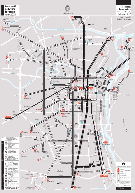
Here goes my last transit mapping project. A high frequency map of the public transport system of Turin, explicitly entitled: … More

Design, GraphicDesign, Graphisme, GraphismeInformatif, HighFrequencyMap, Illustrator, InformationDesign, Map, PlanDeRéseau, Public Transit System, PublicTransitCartography, SystemMap, Torino, TransitMap, TransportsCollectifs, Turin, VectorMap

Detroit Transit Map and Guide to frequency of Service, 2017

Detroit Transit Map

Detroit, Graphic Design, Infographics, Information Design, Network Map, Public Transit System, Transit Map, Transit System

  • cityandtransitmaps's avatar cityandtransitmaps
Blog at WordPress.com.
  • Subscribe Subscribed
    • City & Transit Maps
    • Already have a WordPress.com account? Log in now.
    • City & Transit Maps
    • Subscribe Subscribed
    • Sign up
    • Log in
    • Report this content
    • View site in Reader
    • Manage subscriptions
    • Collapse this bar