Skip to content

City & Transit Maps

  • Analysis/On Maps…
  • Quick bio
  • Une rapide bio
  • WordPress.com
  • More about Transit Maps

Aurélien Boyer-Moraes is a graphic designer hailing from France, specialised in cartographic and information design.

  • Home
  • About
  • Transit Maps
  • City Maps
  • Villes Bis
  • Contact

Tag: Toulouse

Transports publics de Toulouse, 1974

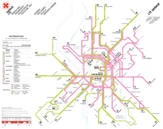
Un nouveau «plan-témoin» d’un réseau à une époque, à Toulouse, en 1974.

Cartography, Map, mobilité, PlanDeRéseau, PublicTransit, SystemMap, Toulouse, TransitMap, Transportspublics

Toulouse public transport draft from Autumn 2013

Apropos my very recent discovery of a sketch of the public transit map of Toulouse from the late 1960s (or … More

Cartography, GraphicDesign, NetworkMap, PublicTransit, Toulouse, TransitMap

Toulouse Transit System schematic map, prototype 10-2013

Update (about the fate of this map)

Cartography, GraphicDesign, InformationDesign, Map, PublicTransit, Schematic Map, SystemMap, Toulouse, TransitMap

  • cityandtransitmaps's avatar cityandtransitmaps
Blog at WordPress.com.
  • Subscribe Subscribed
    • City & Transit Maps
    • Already have a WordPress.com account? Log in now.
    • City & Transit Maps
    • Subscribe Subscribed
    • Sign up
    • Log in
    • Report this content
    • View site in Reader
    • Manage subscriptions
    • Collapse this bar